Why GNSS Jamming Demands a New Approach for Armored Fighting Vehicles
Share:
Published on:
Article Summary
The Challenge: GNSS jamming compromises an armored vehicle’s combat systems and situational awareness, creating an unacceptable risk of mission failure.
The Solution: Advanced Navigation’s inertial navigation systems use fiber-optic gyroscopes, north-seeking gyrocompasses, fusion software, and electronic protection capabilities to provide an armored fighting vehicle with accurate positioning despite GNSS jamming.
The Outcome: Armored fighting vehicles can overcome GNSS jamming, maintaining combat effectiveness and turning a key vulnerability into an offensive advantage.
During the 1991 Gulf War, General Norman Schwarzkopf faced a monumental challenge.
The plan for Operation Desert Storm was a massive armored envelopment – a “left hook,” that would sweep deep into the Iraqi desert, outflanking and cutting off the entrenched Iraqi Republican Guard.
It was a maneuver on a scale not seen since World War II, involving hundreds of thousands of troops and thousands of armored vehicles.
But how could such a vast force navigate through a desolate, sandy expanse with no landmarks, day or night, and maintain the speed and coordination necessary for success?
The answer came from a nascent technology, then in its infancy – the Global Positioning System (GPS). Small teams equipped with early GPS receivers, known as the Small Lightweight GPS Receiver (SLGR), or “slugger,” were distributed among the coalition forces.
For the first time in history, commanders and vehicle crews could know their precise location in the middle of nowhere.
The left hook was a success.1 It surprised Iraqi forces and was a demonstration of how space-based positioning, navigation, and timing (PNT) could fundamentally change land warfare. It broke previous limitations and ushered in an era where the armored fighting vehicle became inextricably linked with the signals from satellites orbiting thousands of kilometers above.
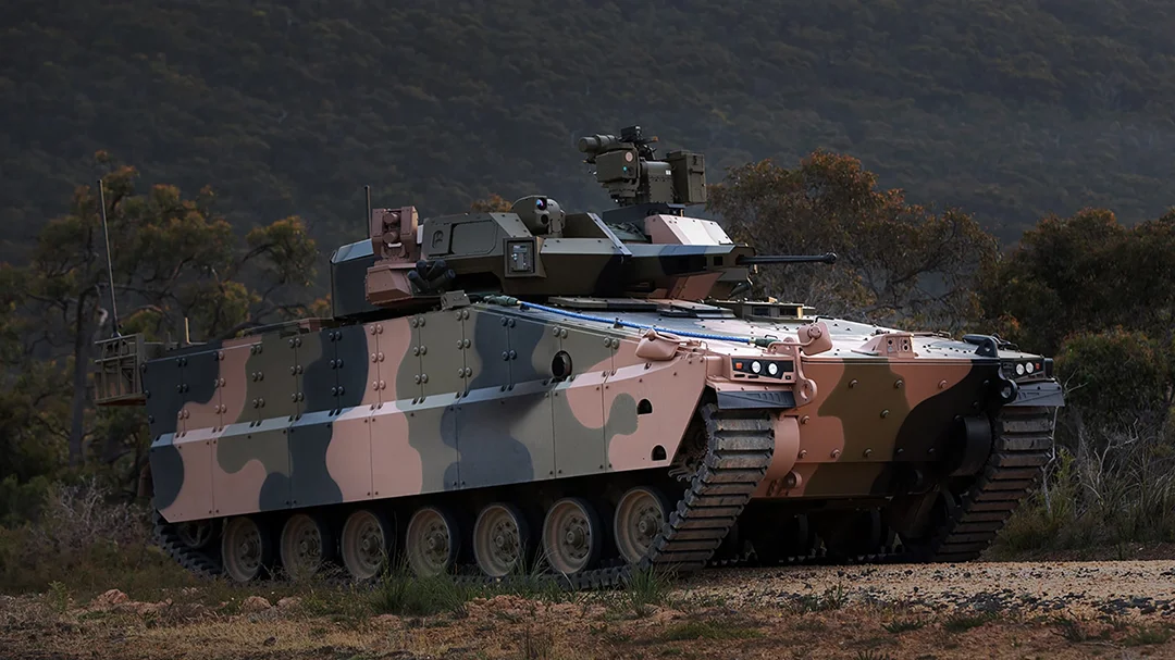
Fast-forward to today, and that reliance has grown exponentially. Modern mechanized infantry and armored cavalry units depend on the Global Navigation Satellite System (GNSS) for nearly every aspect of their defense operations.
From situational awareness and blue force tracking on a digital battle map to the precise targeting of advanced weapon systems, GNSS is the invisible thread that connects and enables the modern armored force.
However, this critical dependency has become a vulnerability. The signals that enabled Schwarzkopf’s battle tactics in 1991 are now under threat in 2025 due to the rapid development of the adversaries capabilities coupled with the increasingly complex nature of modern battlefields and conflict zones.
For the crews and leaders of modern armored fighting vehicles, operating in a world of sophisticated electronic warfare, the risk of GNSS jamming is an operational reality that threatens mission success and warfighter safety.
Is Your Navigation Stack Compromised?
Everything can be jammed. Everything can be spoofed. Find out how to achieve assured PNT with Electronic Protection that outpaces the threat.
Download the report

The Threats of GNSS Jamming
When an armored fighting vehicle loses its GNSS signal, the consequences are immediate and severe. It typically results in cascading failures that unravels the platform’s ability to shoot, move, and communicate effectively.
Compromised Situational Awareness
The most immediate impact of GNSS jamming is the loss of situational awareness:
- The blue icon representing a friendly vehicle on a commander’s digital map begins to drift, becomes inaccurate, or disappears entirely.
- This digital fog of war creates confusion and hesitation.
- Crews can no longer be certain of their own position relative to the objective, enemy forces, or adjacent friendly units.
This loss of digital clarity has devastating tactical implications. True situational awareness is a complex cognitive process of understanding the relationship between three key elements: the enemy, the physical environment, and friendly forces. When PNT data is lost, a commander’s ability to identify friend versus foe deteriorates. They can no longer make informed decisions with confidence. Is that heat signature an enemy vehicle or a friendly straggler? What lies behind that target? Without a reliable position, the risk of collateral damage increases dramatically, hindering operations in populated areas.
Furthermore, modern warfare is increasingly pushing mechanized infantry into complex urban environments. These settings are challenging for GNSS due to signal-blocking buildings (urban canyons) and multi-path interference. In these congested battle spaces, the need for precise spatial awareness is even more acute. An error of a few meters can mean the difference between clearing the correct building or tragically engaging non-combatants or friendly forces.
Without reliable position data, navigation reverts to traditional, inefficient, methods such as map and compass or terrain association – a significant step backwards. This reversion to analog methods represents a failure to meet both the measures of performance and measures of effectiveness demanded of a modern digital platform.
Instead of focusing on tactical decisions, such as identifying threats, directing fires, and maneuvering their element, your crews are consumed by the fundamental task of figuring out where they are.
Degraded Weapon Systems and Mission Command
Modern weapon systems on an armored fighting vehicle are typically tightly integrated and rely on precise PNT data for optimal performance. Fire control systems use the vehicle’s exact location and, just as critically, its orientation (which way the hull and turret are pointing) to calculate firing solutions. This is essential for everything from ballistic compensation for the main armament to cueing remote weapon stations.
Without accurate and continuous heading and attitude data, the platform simply cannot aim effectively. Likewise, the ability to call supporting arms is deteriorated because they are not able to confidently identify weapons or exclusion zones, for their own location for polar missions.
Mission command systems that orchestrate the movement and fires of entire formations falter. The seamless flow of data that allows for combined arms maneuver breaks down, forcing units to operate without mutual support.
The Specter of Fratricide
Perhaps the most harrowing risk associated with GNSS denial is the increased likelihood of fratricide, or “blue-on-blue” engagements.
Accurate blue force tracking is the cornerstone of modern battlefield deconfliction. It allows commanders to safely coordinate movement, establishing clear arcs of fire for different units to ensure they can identify and engage the adversary without endangering each other. When GNSS jamming erodes the integrity of this system, the certainty of who is friendly and who is hostile diminishes, and the entire deconfliction process breaks down.
In a contested environment with limited visibility, complex terrain, and multiple units converging on an objective, the inability to reliably track friendly forces creates an unacceptable level of risk.
The Urgent Need for Assured PNT
The challenges posed by GNSS jamming highlight a clear and present need for assured PNT.
Assured PNT is not about replacing GNSS/GPS but about augmenting it, creating a resilient and redundant system that can provide accurate spatial data even when satellite signals are unavailable or untrustworthy.
For the armored fighting vehicle and mechanized infantry forces, achieving assured PNT is a tactical imperative that creates opportunities your adversary may not expect. A vehicle equipped with a resilient navigation system can maintain its operational tempo inside an enemy’s anti-access/area denial (A2/AD) bubble. This allows planners to achieve a navigational advantage, designing maneuvers through jammed territory that would be impossible for a less-equipped force; a modern-day echo of the navigational superiority that enabled Schwarzkopf’s left hook during the Gulf War.
Imagine a scenario where an adversary initiates a powerful GNSS jamming campaign. Units relying solely on GNSS are immediately compromised. But a force with assured PNT exploits this. They can maneuver through terrain the enemy believes is impassable from a navigational standpoint, creating surprise and seizing the initiative.
This is the power of resilience. It turns a defensive capability into an offensive force multiplier, ensuring mission success by leveraging the foundational data upon which all other battlefield functions depend.
Is Your Current INS Part of the Problem?
The urgent need for assured PNT has led to the integration of inertial navigation systems (INS) on modern defense platforms. However, not all systems are created equal. Many armored vehicles are still equipped with legacy INS solutions that, while better than GNSS alone, create a false sense of security.
These incumbent systems are often tightly coupled to GNSS, meaning they perform well when a signal is present but suffer from rapid performance degradation and high drift the moment it’s lost. Furthermore, many rely on older technologies that are susceptible to the shock and vibration inherent in combat operations.
Worse, these legacy systems are frequently bound by ITAR restrictions, creating supply chain risk and delaying procurement. The real challenge is fielding advanced, resilient, independent, and unrestricted navigation technology that can deliver on the promise of assured PNT.
Delivering Certainty in Chaos
At Advanced Navigation, our products provide the resilient and redundant assured PNT solution required for an armored fighting vehicle to operate with confidence in GNSS-denied or degraded environments.
Unlike legacy defense solutions that are often ITAR-controlled, creating alliance interoperability headaches and procurement delays, our systems are ITAR-free.
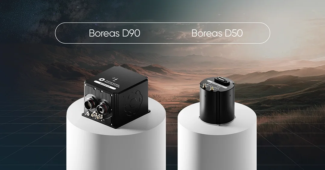
Advanced Navigation offers a range of INS products purpose-built for these demanding scenarios. This includes our ultra-high performance Boreas D90 and our Boreas D50, both compact fiber-optic gyroscope (FOG) INS solutions that are optimized for rugged environments and delivers reliable performance in a low SWaP-C package ideal for retrofits and new vehicle designs, with built-in electronic protection capabilities. Moreover, both products offer a north-seeking gyrocompass that delivers accurate heading and orientation independent of unreliable GNSS and magnetic compasses. The Boreas D50 in particular offers a north-seeking capability in a compact form factor for vehicles that may have SWaP-C requirements.
While traditional systems may rely on older RLG technology that can be sensitive to shock and vibration, our FOG technology provides superior resilience and reliability in the harsh environment of an armored vehicle, tested to MIL-STD-810H.
Beyond the hardware, the core intelligence of our INS lies in our advanced sensor fusion software. This algorithm synthesizes data from a wide array of external sensors, including GNSS, odometers (wheel-speed sensors), and Doppler Velocity Logs (DVLs). This deep fusion approach is a differentiator from legacy systems that are merely ‘GNSS-coupled’. As a consequence of intelligently weighing and cross-validating all incoming data, our system can identify and reject erroneous signals, ensuring a continuous, high-accuracy PNT solution even when GNSS is intermittent, degraded, or completely denied.
Built-in Electronic Protection
Across our range, we provide product variants with electronic protection capabilities, including anti-jamming and anti-spoofing capabilities.
Our products can identify and mitigate interfering signals, allowing the receiver to maintain a lock on satellite signals in environments where lesser systems would fail. Spoofing detection ensures that the vehicle recognizes and counters false location data by an adversary, protecting against digital deception.
Reliable Supply Chain
Our reliability extends further to our rapid production and delivery. Unlike competitors who depend on complex, multi-national supply chains vulnerable to disruption, our vertically integrated manufacturing provides supply chain sovereignty.
For you, this means mitigating risk in your production line with predictable, reliable delivery schedules that are immune to geopolitical friction that can derail a program.
Operate With Confidence
At Advanced Navigation, we provide that position and heading assurance, so the end-user never has to doubt their position or spend even a few seconds confirming it.
Your frontline crews have enough to deal with on the battlefield and should not have to second-guess their navigation system. Your mission is to make their lives easier so they can focus entirely on their primary role.
Our products are designed to remove the cognitive burden of navigation and provide reliable and accurate positioning and orientation data, freeing your tactical vehicles to act with certainty in their spatial awareness.
Through integrating robust, resilient, and independent assured PNT solutions, we can ensure that your mechanized infantry and armored forces will never have to fight blind.
To learn how Advanced Navigation’s range of resilient inertial navigation systems can protect your armored vehicle program, contact our experts today.
References
- Donald P. Wright. “Deception in the Desert: Deceiving Iraq in Operation DESERT STORM”. Army University Press. Accessed at https://www.armyupress.army.mil/Books/Browse-Books/iBooks-and-EPUBs/Deception-in-the-Desert/
FAQs
How does your INS integrate into a modern armored fighting vehicle, and what is its SWaP-C impact?
Our INS solutions are designed for straightforward integration into any armored fighting vehicle architecture, offering common communication interfaces, including Ethernet, CAN, and RS422. Products such as our Boreas D50 are engineered for a low SWaP-C footprint (weighing only 910 grams and consuming less than 10 watts of power), making them ideal for both new vehicle designs and technology insertion programs. This minimizes the engineering burden and platform impact when fielding a robust capability to counter GNSS jamming.
What are the programmatic advantages of your systems being ITAR-free?
Our systems are ITAR-free, which provides a significant programmatic advantage. It eliminates complex export licensing requirements, simplifying procurement and enabling seamless collaboration with NATO and other international partners. This, combined with our vertically integrated manufacturing, ensures a secure supply chain and predictable delivery schedules, de-risking the production and deployment of any armored fighting vehicle program.
Recent Tech Articles
How Improved Positional Accuracy Can Transform Mining Excavation
Explore the new standard in absolute positioning for GNSS-denied environments. See how the Chimera Land LVS and INS pairing anchors real machine motion.
15 June 2026
Go to Article
High-Precision Navigation at Scale for Counter Drone Technology
Unlock precision for your kinetic effector on-the-move. Discover how Advanced Navigation delivers the stabilization and supply chain speed needed for scalable counter drone defense.
18 May 2026
Go to Article