Real Flight Data, Real Results: Demonstrating INS Aiding Tech for GPS-Denied Navigation
Share:
Published on:
Article Summary
The Challenge: When GNSS signals degrade or fail, air platforms lose trusted positioning, making GPS-denied navigation a critical threat to mission success and platform survivability.
The Solution: Advanced Navigation demonstrated two assured navigation architectures using intelligent sensor fusion. The trials paired a Boreas D90 FOG INS with a Laser Velocity Sensor (LVS), and a Certus Evo MEMS INS with an Air Data Unit (ADU), validating resilience across distinct SWaP-C profiles.
The Outcome: A resilient navigation architecture capable of maintaining accuracy even when individual sensors degrade or drop out. The results demonstrate the power of intelligent sensor fusion in delivering assured navigation performance, through jamming, spoofing, and environmental degradation.
- Certus Evo (MEMS INS) + Air Data Unit (ADU):
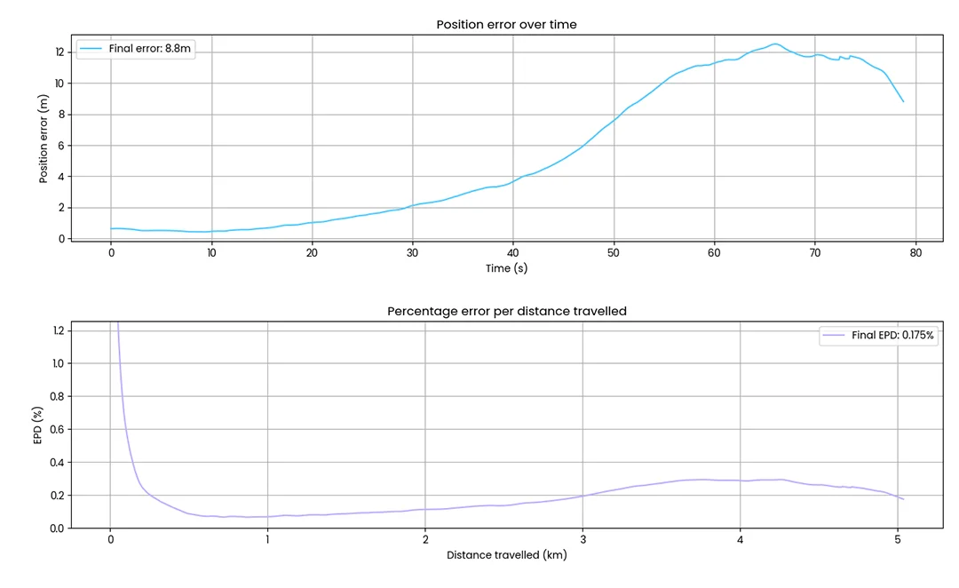
- Over 5 km travelled, achieved only 8.8 m error (0.17% of distance) without GNSS
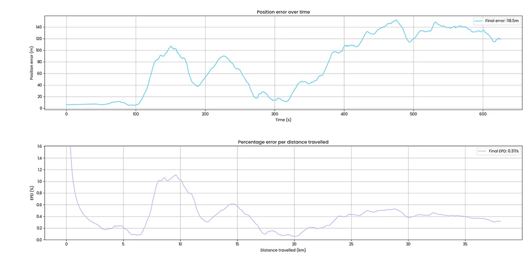
- Over 35 km travelled, achieved only 118 m error (0.3% of distance) without GNSS
- Boreas 90 (FOG INS) + Laser Velocity Sensor (LVS):
- Over 100 km travelled, achieved only 29 m error (0.03% of distance) without GNSS
Intelligent Sensor Fusion for the Next Era of Flight
As global navigation threats continue to escalate, operating in GPS-contested or denied environments has become one of the most critical challenges facing aviation. When GNSS signals degrade, jam, or cannot be trusted, aircraft lose the ability to determine their exact position – putting missions, assets, and lives at risk.
Advanced Navigation is redefining what it means to fly with confidence in these environments. By fusing inertial navigation with complementary aiding technologies through intelligent software, we have demonstrated that precise, reliable navigation is possible even when the signal disappears or is under severe electromagnetic warfare conditions.
The Demonstration: Intelligent Fusion in Action
Rather than depending on a single technology, Advanced Navigation’s architecture intelligently fuses data from multiple sensors in real time, adapting dynamically to signal degradation, vibration, and atmospheric conditions. Operating under Advanced Navigation’s sophisticated AdNav Intelligence, the filter blends bleeding edge state estimation with AI and machine learning techniques to deliver robust, adaptive performance. This approach ensures continuity of navigation through GPS-denied environments when traditional systems fail, enabling pilots and autonomous platforms alike to operate safely and effectively in the most contested air domains – from defence and aerospace to uncrewed aerial vehicles.
In a recent series of flight demonstrations, Advanced Navigation operated two distinct navigation solutions designed to validate assured navigation performance across diverse flight profiles and customer specific SWaP-C (Size, Weight, Power, and Cost) requirements.
Customer applications range from:
- Uncrewed Aerial Systems (UAS)
- Vertical Take off and Landing (VTOL)
- High-Altitude Pseudo-Satellite (HAPS)
- Medium Altitude Long Endurance (MALE)
- High Altitude Long Endurance (HALE)
- Long-endurance ISR Platforms (ISR)
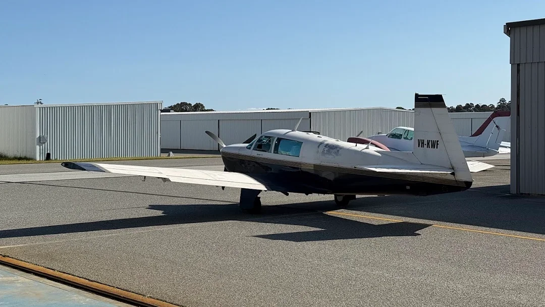
The demonstrations were conducted aboard a Mooney 201 (M20J) aircraft operating at altitudes between 400 and 500 metres in deliberately GNSS-denied conditions, replicating the complexity and volatility of modern contested airspace.
Flights departed from Jandakot Airport in Western Australia, with data collected across expansive farmland and dense forest throughout the South West region. These trials enabled evaluation of navigation resilience across dynamic manoeuvres, varying terrain, and changing atmospheric conditions.
Lightweight Drones Flying up to 50 km without GNSS
The first intelligently fused a Certus Evo Inertial Navigation System (INS) with an Air Data Unit (ADU), enabling continuous estimation of position and velocity through atmospheric data.
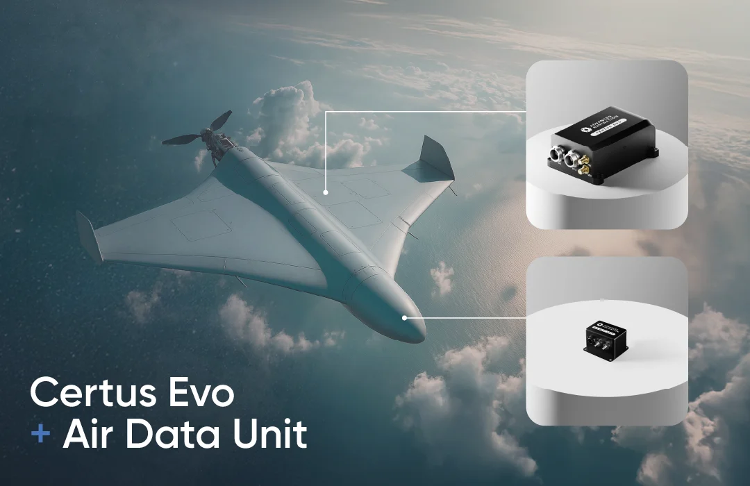
Certus Evo (MEMS INS)
Certus Evo is a MEMS INS that provides extremely accurate position, velocity, acceleration, and orientation under the most demanding conditions. It offers FOG-like performance combined with the reliability and affordability of MEMS sensors. It features low SWaP-C, internal data logging, and multiple communication interfaces for easy integration. Equipped with Electronic Protection (EP) capabilities, it’s purpose-built to counter electromagnetic warfare (EW) threats.
Air Data Unit (ADU)
The Air Data Unit is used to measure pitot airspeed and barometric altitude in fixed-wing aircraft. It features high accuracy temperature calibrated pitot and static air data sensors and outputs data over RS232. It can be used standalone or connected to one of Advanced Navigation’s INS products for outstanding navigation accuracy in fixed-wing aircraft when GNSS is not available.
Configuration
This configuration was designed for small uncrewed aircraft that require low weight, low cost and high reliability. The Certus Evo was installed inside the aircraft along with the ADU connected to the plane’s pitot tube. The INS used the aircraft’s GNSS antenna for initialisation before GNSS was denied during the flight.
Performance
Over 5 km of flight, the system achieved an error of just 8.8 metres – a remarkable 0.17% of the total distance travelled.
Over a longer 35 km mission, the same setup achieved 118 metres of error, maintaining 0.3% accuracy despite GNSS signal absence.
This level of performance is highly relevant for uncrewed aerial systems (UAS), VTOL aircraft, HAPS platforms, and long-endurance ISR missions that must operate in denied airspace over roughly 50 km and rely on light, low-power solutions to maintain precise positioning.
Long-range and High-dynamic Flight Missions Greater Than 100km without GNSS
The second pairing involved the Boreas D90, Advanced Navigation’s flagship Fibre Optic Gyroscope (FOG) INS, fused with a Laser Velocity Sensor (LVS).
This configuration was designed for long-range missions, ISR platforms, helicopters, and fast-moving fixed-wing aircraft that demand strategic-level accuracy and long-term stability.
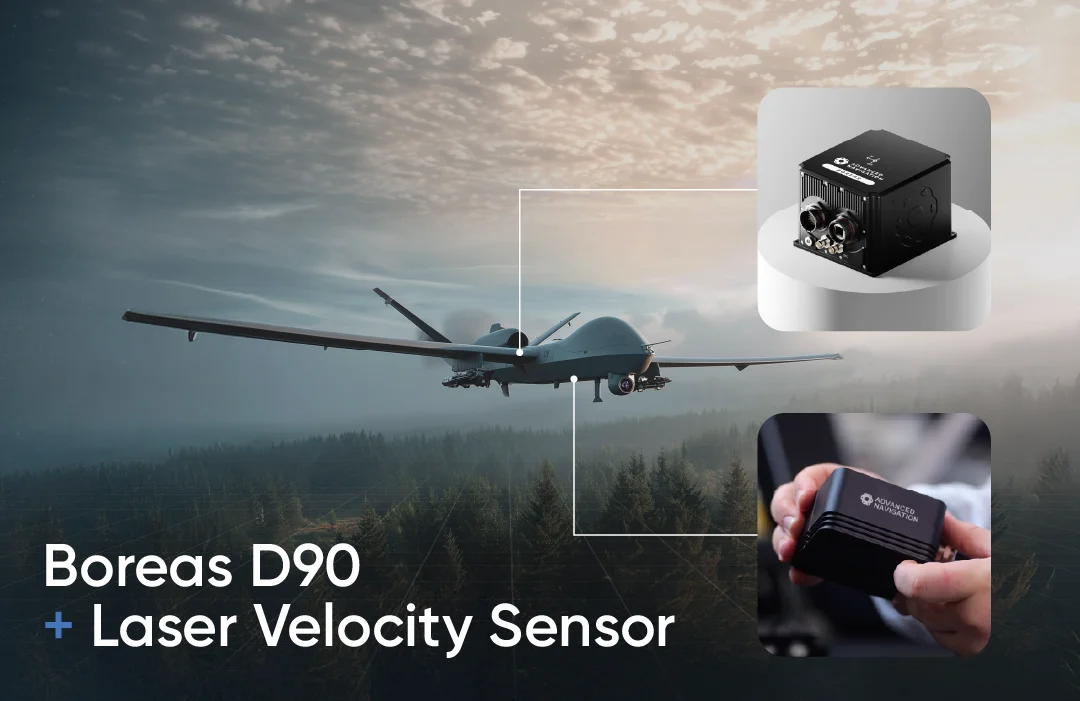
Boreas D90 (FOG INS)
Boreas D90 is a rugged FOG INS that can determine heading without needing a GNSS or a magnetometer. By sensing the Earth’s rotation, the system’s north-seeking algorithm can acquire an accurate heading. This is possible in static and dynamic conditions, even at high latitudes. Purpose-built to counter electromagnetic warfare (EW) threats, it is equipped with Electronic Protection (EP) capabilities against GNSS jamming and spoofing.
It features multiple interfaces, including Ethernet, CAN, RS232, 1PPS, RS422, and GPIOs. It supports industry standard protocols, including NMEA 0183, CANopen, 1PPS, and ANPP, as well as a wide variety of proprietary protocols.
Laser Velocity Sensor (LVS)
The Laser Velocity Sensor (LVS) is a new class of navigation technology developed by Advanced Navigation for precise and accurate velocity-aiding. The novel sensor measures 3D velocity using laser Doppler velocimetry, offering exceptional accuracy and long-term stability compared to other sensors. Unlike conventional velocity sensors, LVS operates effectively on both ground and airborne platforms, provided it has a clear line of sight to the ground or another stationary surface.
Configuration
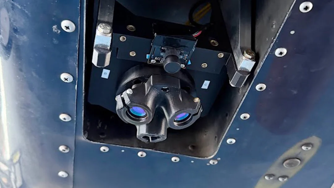
This configuration was designed for small uncrewed aircraft that require low weight, low cost and high reliability. The Boreas D90 was installed inside the aircraft, while the LVS optical head was directly below the INS, pointing to the ground. The INS used the aircraft’s GNSS antenna for initialisation before GNSS was denied during the flight.
Performance
Over 100 km, the system recorded only 29 metres of error – a mere 0.03% of the total distance.
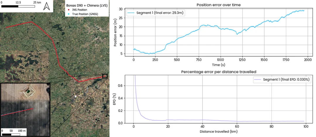
This represents an order-of-magnitude improvement over conventional velocity aiding techniques, supporting precise navigation even during GNSS denial.
Recommended for Uncrewed Aerial Systems (UAS), Vertical Take off and Landing (VTOL), High-Altitude Pseudo-Satellite (HAPS), Medium altitude long endurance (MALE), High altitude long endurance (HALE) and Long-endurance ISR Platforms (ISR) operating in heavily contested, GPS-denied airspace beyond 100 km and rely on strategic-grade, high-accuracy solutions to maintain long-term precise positioning.
The Future: Resilience in Every Flight Path
The results reinforce the power of software-defined navigation for A-PNT, delivering key advantages:
- Resilience against jamming and spoofing
- Flexible integration of classified or sovereign algorithms
- Scalable SWaP-C profiles from micro-UAS to longe range platforms
- Rapid configuration for mission-specific payloads
- Reduced dependence on vulnerable external signals
- Survivable navigation in denied, disrupted, or deceptive environments
As global reliance on GPS continues to expose critical vulnerabilities, the need for intelligent, resilient alternatives has never been greater. Across aviation, uncrewed systems, VTOL aircraft, HAPS platforms, long-endurance ISR missions, and commercial applications that demand precision and safety, assured navigation is emerging as a defining capability.
Advanced Navigation’s intelligent fusion of inertial systems with novel aiding sources offers a clear path toward navigation independence, maintaining accuracy and continuity even when external signals fail.
FAQs
What is AdNav Intelligence Fusion?
AdNav Intelligence Fusion is Advanced Navigation’s software-defined sensor fusion architecture that blends inertial data with multiple aiding technologies in real time. Its sophisticated algorithms use a combination of advanced state estimation, AI, and machine learning to continuously adapt to jamming, spoofing, vibration, and changing environmental conditions.
The result is resilient, high accuracy navigation even when GPS is denied or other sensor signals degrade or disappear, supporting everything from uncrewed aerial systems, land robotics, autonomous vehicles, maritime and subsea platforms to space systems.
What is the difference between a MEMS INS and a FOG INS?
A MEMS INS, such as Certus Evo, uses micro-electromechanical inertial sensors to deliver high accuracy in a lightweight, low-SWaP-C, and cost-effective form. It is ideal for small UAS, VTOL aircraft, HAPS platforms, and missions of up to around 50 km without GNSS, offering near-FOG performance while remaining optimised for size, weight, power, and affordability.
While a FOG INS such as the Boreas D90 uses fibre optic gyroscopes to achieve strategic-grade precision with exceptional long-term stability and accuracy. This class of system is suited to long-range, high-dynamic missions beyond 100 km, supporting ISR aircraft, helicopters, and other high-performance platforms. When paired with advanced aiding technologies like the Laser Velocity Sensor, it delivers an order-of-magnitude improvement in overall navigation performance.
In short, MEMS provides compact, affordable, high performance, while FOG delivers strategic-grade accuracy for the most demanding long-range missions.
How can I purchase the Laser Velocity Sensor?
Advanced Navigation’s Laser Velocity Sensor (LVS) for Air applications is currently available for select early-adopter programs.
If you’re looking to integrate a FOG INS fused with a LVS into an upcoming platform or mission profile, our sales team can support you with technical guidance, timelines, and evaluation options tailored to your application.
If you are looking for a land application – Chimera Land Laser Velocity Sensor is available: https://www.advancednavigation.com/accessories/velocity-aiding/chimera-land/
Recent Tech Articles
How Improved Positional Accuracy Can Transform Mining Excavation
Explore the new standard in absolute positioning for GNSS-denied environments. See how the Chimera Land LVS and INS pairing anchors real machine motion.
15 June 2026
Go to Article
High-Precision Navigation at Scale for Counter Drone Technology
Unlock precision for your kinetic effector on-the-move. Discover how Advanced Navigation delivers the stabilization and supply chain speed needed for scalable counter drone defense.
18 May 2026
Go to Article