
How to Achieve High-Accuracy Underground Drill Rig Alignment
Share:
Published on:
Article Summary
The Challenge: Inaccurate underground drill alignment can cause lost production due to missed ore, poor fragmentation or developing along the wrong heading, all of which may require costly re-work.
The Solution: Advanced Navigation’s Boreas is a robust FOG-based INS range that provides consistently accurate alignment for underground drilling operations.
The Outcome: Improve profitability through precisely drilled patterns that maximize ore recovery, optimise blast efficiency, and increase overall productivity.
We know that you live by the numbers.
Metres drilled, patterns completed, and the tonnages achieved per shift are the metrics that define your success.
Every decision that you make at the face has a ripple effect on the entire operation, from blasting to mucking, and even hauling.
But what if one of the most significant sources of lost revenue and operational inefficiency is happening before the drill even starts turning?
When it comes to underground drill rig alignments, small alignment errors or inconsistent alignment can mean missing your target. What might seem to others as simply a minor deviation, is in actuality lost revenue, increased dilution, and wasted operational expenditure, all equating to money left in the face on your watch.
The Domino Effect of a Poor Start
You’ve seen it happen many times before.
During development, a pattern is drilled based on what was thought to be the right heading. The blast doesn’t pull as expected. The fragmentation might be poor, or the profile is not as expected, and/or more de-scaling is required, which delays mucking, leaving your LHDs and haulers sitting idle.
Drilling inaccuracy can lead to one or more of the following, depending on the mining technique employed:
- Deviation from the plan: A poor drill pattern can result in heading development deviation, potentially introducing a dogleg to your development drift.
- Inefficient blasting: Similarly, poor drill patterns lead to subpar fragmentation e.g. oversized rocks or too many fines, which impacts loading efficiency.
- Increased dilution: Blasting too close to the hanging wall or into the previously caved-in rock captures more waste rock, driving up processing costs.
- Costly re-work: Time and resources are wasted when corrections are necessary, including lost opportunity costs and the additional wear-and-tear on the equipment.
Why Existing Navigation Solutions Fall Short
For years, you’ve tried to solve this problem with the tools available. But both ends of the technology spectrum present significant challenges.
On one hand, many operations have experimented with highly specific, low-rate MEMS-based northfinders that over-promise and under-deliver. The reality is that these systems are operating at the absolute limit of their physical capabilities against the temperature and vibration commonly found underground. They lack the performance headroom to handle the subtle vibrations, movement, and harsh conditions of an active underground mine. The result is often unreliable data, lengthy setup times waiting for them to settle, and a lack of trust from your operators. They simply aren’t robust enough for the job, so operators often resort to having their surveyor align the rig manually, or not at all.
On the other hand, ultra-high performance, ITAR-controlled, imported military-grade systems can deliver the required accuracy, however, their price point often makes them unjustifiable for an entire fleet of drill rigs. They are a solution reserved for niche applications, rather than as a standard operational tool.
This leaves a wide, frustrating gap in mine drilling technology between systems that are affordable but don’t work reliably, and systems that work but are inaccessible to the majority.
Strategic-Grade Navigation for Every Rig
This performance gap, between unreliable, low-cost sensors and prohibitively expensive systems, has left a critical need in the mining industry.
This is where the Boreas 50 Series comes in.
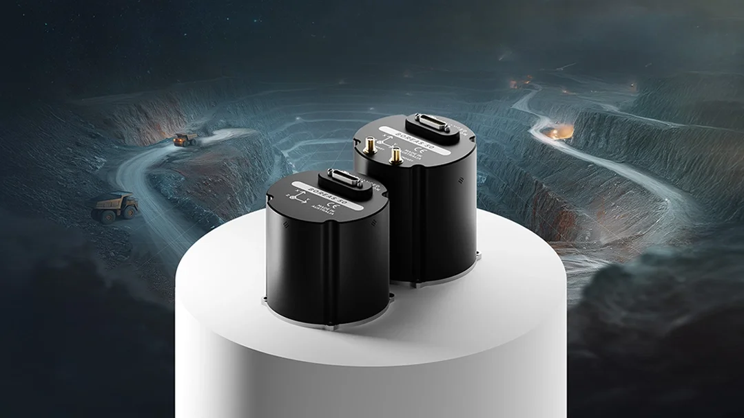
Our new Boreas A50 and D50 are high-performance, Australian-produced, north-seeking and orientation systems. They are specifically designed to deliver accurate and consistent drill rig alignment in the demanding conditions of underground mining.
Using our FOG technology, Boreas delivers the three critical data points you need (roll, pitch, and heading) with a level of reliability and usability that directly impacts your bottom line. Furthermore, by integrating vehicle odometry as an aiding source, the system is also capable of providing positioning and heading underground, providing an additional layer of localization.
Here’s how Boreas provides a distinct advantage over imported or out-of-date systems:
Built for the realities of underground drilling
A key challenge with delicate alignment systems is the need to mount them for a reading and then remove them before drilling begins. Though still necessary for certain long hole drills, a rig-mounted alignment solution of sufficient accuracy is enough for a significant portion of drilling activity. Boreas 50 is engineered for permanent integration; designed to be a robust solution, such that the vibration and motion when positioning the rig does not impact performance precision, and it is tough enough to remain on the rig without removal (designed to MIL-STD-810H). This simplifies the workflow for your operators and ensures consistent performance, shift after shift. Furthermore, its compact and tough design expands the possibility of mounting the system to a drill’s drive unit in some cases.
Boreas finds its orientation and keeps it
Unlike MEMS-based systems that struggle with vibration, Boreas 50 has the performance headroom to determine its heading relative to true north, and accurately track orientational changes in real-time, including while the rig is being positioned. This means your operators get a fast, accurate, and repeatable rig alignment, both during and between drill patterns.
Local innovation, global performance
Developed in Australia, the heart of mining, Boreas 50 is the result of local industry expertise and methodically-tested engineering. This technology is the combination of cutting-edge design and worldwide accessibility that provides a reliable and powerful competitive advantage on almost any continent. Moreover, our products are backed by a vertically-integrated, resilient supply chain, so you avoid procurement delays and get the technology you need, when you need it.
From Better Alignment to a Better Bottom Line
Integrating the Boreas 50 is about making a strategic investment in the fundamentals of your development process.
The Boreas 50 Series will empower you to close the gap between inaccurate, low-cost sensors and unaffordable high-end, highly-controlled systems, and equip your team with the tools they need to execute the plan and maximize ore recovery.
To learn more about how inertial navigation systems can significantly improve your drilling accuracy and profitability, get in touch with the team at Advanced Navigation.
FAQs
Why do many alignment sensors lose accuracy with rig vibration?
Many conventional MEMS-based sensors lack the performance headroom to filter out the vibrations of an active mine. The Boreas 50 Series not only outperforms these devices, but is engineered for these harsh conditions, featuring a rugged, IP67-rated design that is dustproof, shock, and vibration resistant. This robust build allows it to maintain a stable and reliable heading even when the rig is being re-positioned without waiting for it to re-settle or suffering from data unreliability.
How does the Boreas 50 Series differ from other MEMS or high-end FOG systems?
The Boreas 50 bridges the gap between unreliable low-cost MEMS sensors and prohibitively expensive and oversized positioning systems. The Boreas 50 is a compact, northseeking high performance FOG that delivers the reliability needed for mine drilling, but at a price point that makes outfitting a fleet of underground drill rigs operationally justifiable.
Recent Tech Articles
How Improved Positional Accuracy Can Transform Mining Excavation
Explore the new standard in absolute positioning for GNSS-denied environments. See how the Chimera Land LVS and INS pairing anchors real machine motion.
15 June 2026
Go to Article
High-Precision Navigation at Scale for Counter Drone Technology
Unlock precision for your kinetic effector on-the-move. Discover how Advanced Navigation delivers the stabilization and supply chain speed needed for scalable counter drone defense.
18 May 2026
Go to Article