
Defending Your Naval Navigation Against GPS Interference
Share:
Published on:
Article Summary
The Challenge: Modern naval architectures face operational risks from sophisticated electromagnetic warfare, where jamming and spoofing corrupt the PNT data required to conduct operations in a contested environment.
The Solution: Advanced Navigation mitigates these threats by integrating electronic protection into ITAR-free inertial navigation systems that transition to precision navigation when it is compromised.
The Outcome: Vessels maintain absolute positioning confidence and combat readiness in fully contested, GPS-denied environments, ensuring mission success through resilient navigation data.
For systems engineers designing the next generation of naval architecture, the challenge has shifted from simply acquiring a signal to validating it.
As adversarial electromagnetic warfare capabilities become more commonplace, the integrity of naval navigation hangs in the balance.
Naval architecture demands PNT resilience that transcends the vulnerability of GNSS. In an era of ubiquitous spectral denial and sophisticated spoofing, the priority shifts from signal acquisition to absolute data integrity.
However, the dependence on satellite signals remains a vulnerability. The accessibility of jamming and spoofing technology means that GPS interference is no longer limited to peer-level adversaries, but rather today is a pervasive threat in almost every contested arena.
How do you design a navigation subsystem that maintains absolute confidence when the primary external reference is actively interfered with?
The solution requires resilient, sensor-agnostic architecture.
The Operational Risks of Naval Navigation
The core problem facing modern naval navigation is not merely the loss of signal, but the corruption of data. Jamming has resulted in a denial of service that forces a fallback to inertial or visual methods, whilst spoofing has introduced subtle errors into the navigation solution, causing a vessel to drift off course or providing false timing data to networked systems.
The implications of this data corruption propagate downstream through the Combat Management System (CMS). When GPS interference compromises the PNT data:
- Tactical latency: Operators and automated systems must spend seconds verifying positioning data against secondary sources (radar, visual, depth) before executing maneuvers.
- Degraded engagement: Weapon systems rely on precise platform attitude and heading to calculate firing solutions. If the navigation feed is suspect, the probability of a successful engagement drops significantly.
- Operational paralysis: In a highly contested environment, the “fog of war” is thickest when a commander cannot trust their own own-ship position. This doubt can delay tactical interpretation, compromising the ability to effectively engage threats.
Electronic Protection Through Advanced INS
The defense against sophisticated GPS interference is not found in a single component, but in a resilient, multi-layered architecture. This approach unpacks the inertial navigation system (INS) into a hierarchy of validation, ensuring that no single point of failure can compromise the vessel’s state estimation.
Rather than relying solely on hardening the GPS receiver, Advanced Navigation focuses on the integrity of the sensor fusion engine. Through utilizing accelerometers, gyroscopes, velocity aids and filtering algorithms, these systems create an internal “truth” that external spoofing cannot easily overwrite.
This architecture delivers deterministic PNT assurance. Utilizing integrity monitoring, the system isolates the platform from RF interference. It detects spoofing characteristics, such as unrealistic velocity gating or clock drift, and transitions to inertial-only without data discontinuities.
Selecting the Right Architecture
The challenge is often matching the performance class of the INS to the specific constraints of the vessel.
Advanced Navigation offers a scalable architecture, ranging from SWaP-C (Size, Weight, Power, and Cost) constrained uncrewed systems to high-value strategic surface combatants.
Moreover, our products are ITAR-free, significantly reducing administrative friction and enabling rapid deployment for allied fleets. Our vertically integrated manufacturing reduces risk from supply chains that can be challenged by geopolitical instability, preventing program delays common with legacy suppliers.
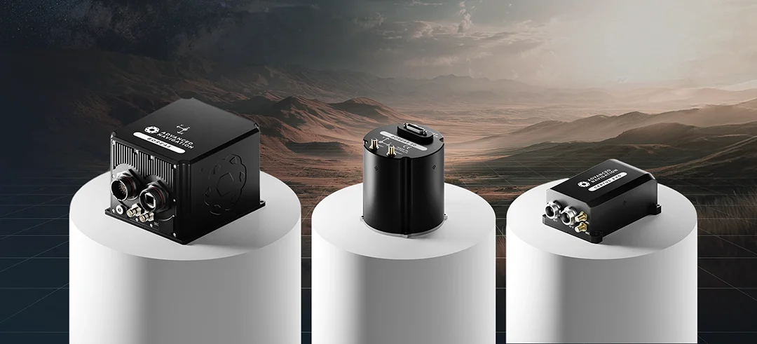
Certus Evo
The proliferation of uncrewed surface vessels (USVs) has created a demand for high-performance navigation in small form factors.
These platforms often lack the power budget or payload capacity for massive fiber-optic systems, yet they traditionally operate in the littoral zones where GPS interference is generally its most intense.
The Certus Evo is the ideal solution for this tier. It represents a leap forward in MEMS (Micro-Electro-Mechanical Systems) technology, delivering best performance for a MEMS in a compact form factor, while offering the lowest SWaP-C profile in its class. Moreover, the Certus Evo offers an electronic protection variant with a multi-band receiver that adds resilience against jamming and spoofing.
Boreas D Series
For high-performance uncrewed underwater vehicles (UUVs) and crewed surface vessels, the requirements for naval navigation integrity are absolute. These platforms may operate submerged for extended periods or engage threats from significant standoff distances.
Advanced Navigation’s Boreas D50, D70, and D90 utilize Fiber Optic Gyroscope (FOG) technology. In a scenario where GPS interference is total (complete denial), the Boreas series offers best-in-class free inertial and dead reckoning performance.
The Boreas D50 in particular, offers fast north seeking capability (accurately determining north from the earth’s rotation) in a compact form factor, ensures that your dead-reckoning error budget is not consumed by heading instability, allowing for extended submerged or GNSS-denied operations with precision.
Protecting Your Fleet
The integration of resilient naval navigation is a fundamental requirement for survivability.
As GPS interference continues to evolve, the reliance on satellite data must be backed by inertial technologies and aiding sources such as DVL.
Advanced Navigation provides you with the toolkit to solve this problem. Whether outfitting USVs with the Certus Evo or retrofitting an advanced surface vessel with the Boreas D90, the result is a navigation solution that remains true, even when the world around it is compromised.
FAQs
What distinguishes the Certus Evo and Boreas FOG series in environments with high GPS interference?
While both systems deliver the “protective blanket” of electronic protection, they represent different points on the inertial performance continuum. The distinction lies in the rate of error accumulation over time. The Certus Evo minimizes drift for SWaP-C constrained tactical operations using MEMS. Moving up the range to the Boreas FOG series, the bias instability decreases incrementally, culminating in the Boreas D90. This system delivers the lowest possible drift rate, significantly extending the operational window in -denied or submerged environments.
Why is an ITAR-free architecture critical for resilient naval navigation programs?
ITAR-free components, such as the Boreas and Certus series, offer significant advantages for naval navigation projects by simplifying international export compliance and reducing supply chain friction. This ensures faster access to inertial technologies capable of withstanding GPS interference, without the restrictive lead times or data-sharing limitations often associated with traditional, export-controlled defense navigation systems.
Recent Tech Articles
How Improved Positional Accuracy Can Transform Mining Excavation
Explore the new standard in absolute positioning for GNSS-denied environments. See how the Chimera Land LVS and INS pairing anchors real machine motion.
15 June 2026
Go to Article
High-Precision Navigation at Scale for Counter Drone Technology
Unlock precision for your kinetic effector on-the-move. Discover how Advanced Navigation delivers the stabilization and supply chain speed needed for scalable counter drone defense.
18 May 2026
Go to Article